Segment 9: From Pitorreal to Nacayvo North
| Segment length |
6.94 km |
| Maximum elevation |
2387 m |
| Minimum elevation |
2281 m |
[2280.067871,2286.156006,2287.693441,2288.488363,2289.29891,2291.794271,2291.604818,2291.778891,2291.783041,2290.861166,2291.015463,2291.041979,2291.254169,2291.258591,2291.280121,2291.196601,2290.791373,2290.628826,2290.675781,2290.703474,2290.399149,2290.527325,2290.437787,2290.113507,2290.448036,2290.199779,2289.545346,2289.309054,2289.14777,2289.156314,2289.848173,2289.625639,2289.046129,2288.495952,2288.450938,2288.696077,2288.602952,2288.418478,2288.390822,2288.956707,2288.879596,2288.903708,2288.839014,2288.409385,2287.69064,2287.108854,2287.536562,2287.097671,2287.143168,2286.967235,2286.332294,2286.268986,2285.366605,2285.29385,2285.038388,2284.588349,2284.746185,2284.394301,2284.049862,2283.778473,2283.642662,2283.479681,2283.173883,2283.07885,2282.767575,2281.799946,2281.74591,2280.980003,2282.44352,2281.859505,2281.285836,2280.670216,2280.486127,2280.089907,2279.470294,2279.516929,2280.244958,2280.465743,2280.507055,2280.947093,2280.724669,2280.546239,2280.846976,2280.348216,2280.150902,2279.81647,2280.182388,2280.140458,2280.439491,2280.541722,2280.40093,2280.414761,2280.329544,2280.637752,2280.786969,2281.000778,2281.396393,2281.438315,2281.242783,2281.574712,2282.191072,2282.512583,2283.455235,2283.778088,2284.324035,2284.459054,2284.55195,2285.370533,2285.609377,2285.732777,2285.77084,2286.004247,2286.488897,2286.553159,2286.681133,2287.031823,2286.908534,2287.654264,2288.037879,2288.108481,2288.196131,2288.378931,2288.837877,2289.534994,2289.654951,2290.287276,2291.171491,2291.706559,2292.046548,2291.945085,2292.17541,2292.028926,2292.009526,2291.882117,2292.01427,2292.677843,2293.000788,2293.54959,2294.005092,2294.293159,2294.536914,2294.43085,2295.367708,2295.92845,2296.206687,2296.548199,2296.788936,2297.634842,2298.374084,2298.565626,2298.751166,2298.898565,2298.971662,2299.256307,2299.819197,2299.872823,2300.750974,2301.110947,2301.782604,2302.105542,2302.327272,2302.920182,2303.606471,2303.840046,2304.093632,2304.408877,2304.818933,2305.011411,2305.294867,2305.469354,2305.533354,2305.275338,2304.933489,2305.050626,2304.777771,2304.170147,2303.51372,2302.950891,2302.693717,2302.099488,2301.908452,2301.335252,2300.860999,2300.60356,2300.021852,2300.097361,2300.244222,2299.721005,2299.544674,2299.025325,2298.811553,2298.929361,2298.660118,2298.231729,2298.024032,2297.920882,2297.995504,2297.605716,2296.982901,2297.369735,2297.563179,2297.190796,2297.444535,2297.311033,2297.116007,2297.099888,2296.846795,2296.795753,2296.742348,2296.916117,2296.46771,2296.636673,2296.53461,2296.695991,2296.573495,2297.2045,2297.381627,2297.267673,2297.295688,2297.206242,2297.051274,2296.894051,2296.394278,2296.299877,2296.069606,2296.325661,2296.483513,2296.361244,2296.21704,2296.007948,2295.601463,2295.327158,2296.032493,2295.980454,2295.777119,2295.676262,2295.307964,2295.367469,2295.825667,2295.38503,2295.585106,2295.515266,2295.396936,2294.962201,2294.746164,2294.502518,2294.558732,2295.131514,2294.995973,2295.012826,2294.505865,2294.295633,2294.091052,2293.701324,2293.565404,2293.58222,2293.154144,2292.588079,2293.257429,2293.172161,2293.21224,2293.010379,2292.446337,2292.267769,2292.801794,2292.35635,2292.350125,2292.680317,2292.654092,2292.720214,2291.871298,2291.857045,2292.092982,2292.081491,2291.731807,2291.415105,2292.2109,2291.1301,2290.733554,2290.867429,2290.84718,2291.134778,2291.154486,2291.105634,2291.366438,2291.419986,2290.903922,2291.019323,2290.950258,2290.363644,2290.478405,2290.463099,2290.498352,2290.075068,2289.764338,2289.216895,2289.630371,2290.081582,2290.331333,2290.608148,2290.091641,2290.26877,2290.309451,2290.682101,2290.494014,2290.970517,2291.352525,2290.898476,2290.594807,2289.686318,2290.542357,2291.503062,2292.315597,2292.383529,2291.576948,2291.561961,2292.636841,2291.6337,2291.30652,2291.478485,2291.98465,2290.819279,2291.207466,2291.650927,2292.094489,2292.269986,2292.384161,2293.258512,2293.68539,2292.656913,2292.157709,2292.050767,2292.074125,2291.7994,2291.651274,2291.016012,2290.97255,2290.800955,2290.204191,2289.662039,2289.99773,2290.560501,2290.168367,2290.082273,2290.120123,2289.739827,2289.459548,2289.210563,2289.420263,2289.709097,2290.462603,2290.350556,2290.059053,2289.716373,2289.384566,2289.972646,2290.234627,2290.771914,2290.121915,2290.073174,2290.393103,2289.986571,2289.730198,2289.908202,2289.91271,2289.471231,2290.453222,2290.201252,2290.065599,2290.695688,2290.423917,2290.252854,2290.420969,2289.895189,2289.670287,2290.325469,2289.862442,2289.875708,2289.83919,2289.877672,2290.455438,2289.391689,2289.455037,2289.680261,2289.47968,2289.096359,2289.138711,2288.218612,2288.481652,2288.853848,2288.570133,2288.771902,2289.173341,2289.1921,2289.419788,2289.275188,2289.109161,2289.649846,2290.114458,2290.18509,2289.841351,2289.910119,2289.930447,2290.173772,2290.844266,2290.177746,2289.882007,2290.077878,2289.978157,2290.584211,2291.210748,2290.967358,2290.322157,2289.972775,2290.274666,2290.275602,2290.25319,2290.740381,2290.489702,2290.769512,2290.8297,2290.851563,2290.730949,2291.183195,2291.053807,2290.945669,2289.82224,2289.751245,2289.321489,2288.805577,2289.162907,2289.144767,2289.049917,2289.221783,2288.97432,2289.098051,2289.243295,2289.972725,2289.949594,2289.655069,2289.322789,2289.330186,2289.439294,2289.64582,2289.305449,2288.716944,2288.611223,2287.754414,2287.707099,2287.797675,2287.593829,2287.71991,2287.810194,2287.137004,2286.6272,2285.336194,2284.310296,2283.928374,2283.329916,2282.996852,2282.817962,2282.647081,2282.84566,2282.364128,2282.61059,2282.784705,2283.365882,2283.863777,2283.597891,2283.528597,2283.408467,2283.072126,2283.827646,2285.008039,2285.255466,2285.601701,2285.736897,2286.385045,2286.939887,2286.916149,2287.152314,2287.34824,2287.428325,2288.742175,2289.257909,2289.525777,2289.584313,2290.047788,2290.930891,2291.117169,2291.491995,2292.186696,2292.234386,2292.369974,2292.944726,2292.874842,2293.441302,2294.509805,2294.01457,2294.02495,2294.454412,2295.16757,2295.659198,2295.796112,2296.174217,2296.39585,2296.792247,2296.829148,2297.098537,2297.317123,2297.18324,2296.997921,2296.483406,2296.661088,2296.696994,2296.956359,2297.50955,2297.770182,2298.049217,2299.113599,2299.814967,2299.877335,2299.882831,2299.954754,2300.141659,2300.081854,2300.321445,2300.182403,2300.280655,2301.192843,2301.776234,2302.124345,2301.99914,2302.293671,2302.070685,2301.790896,2302.178714,2302.625835,2302.744697,2303.161525,2303.520833,2304.016001,2304.306113,2304.552222,2304.746821,2305.043448,2305.657798,2306.594525,2306.845514,2306.858213,2307.968097,2308.683454,2309.095438,2308.710635,2308.96199,2309.411536,2309.818427,2309.935263,2309.925175,2310.693809,2311.392745,2311.702193,2310.583994,2310.598254,2310.953599,2311.167765,2311.44719,2311.87824,2312.392034,2312.523614,2313.295114,2313.88142,2314.401219,2314.869909,2315.310205,2316.111516,2316.699207,2317.138161,2317.940056,2318.768618,2319.020954,2319.717944,2320.768829,2321.122634,2321.781677,2322.296704,2323.534448,2324.008843,2324.545529,2324.687555,2324.895114,2325.723098,2325.860955,2326.51169,2326.799533,2327.879991,2328.695205,2329.10571,2329.183851,2329.375289,2329.542457,2330.074599,2330.630321,2330.542778,2331.104856,2331.885833,2331.853311,2332.109294,2332.682912,2333.913787,2333.43315,2333.766001,2334.24291,2334.537949,2334.012928,2334.518792,2334.801788,2334.471586,2334.331576,2333.59862,2333.718627,2332.846119,2333.74959,2334.067724,2334.039638,2334.147105,2335.023566,2335.761005,2336.892653,2335.876537,2335.857209,2336.407044,2336.357692,2335.865273,2336.971681,2337.606143,2338.783927,2338.359274,2338.261168,2338.279618,2338.246523,2337.794518,2338.102163,2338.450588,2338.902,2338.526879,2338.107286,2338.173103,2337.540867,2337.054557,2336.7114,2337.424786,2337.43137,2337.605127,2337.29433,2336.773455,2337.148183,2337.852276,2337.678101,2337.28647,2337.706174,2337.724091,2337.633267,2337.105478,2336.792693,2336.647531,2336.047149,2335.114446,2334.159918,2333.710949,2333.639781,2333.820444,2334.22215,2334.612295,2334.343179,2334.466897,2334.905007,2334.959847,2334.929217,2334.924444,2334.900078,2334.749585,2334.570118,2334.904679,2334.890931,2335.025822,2334.913533,2334.345247,2334.651708,2334.608337,2334.84776,2334.186492,2334.189579,2333.968787,2334.015256,2333.728945,2333.400734,2333.662812,2333.422695,2333.559012,2333.915649,2334.304464,2334.457048,2334.440326,2334.581494,2334.617501,2335.268874,2335.990906,2335.80818,2336.139549,2336.175714,2335.356192,2335.193619,2335.731354,2336.522778,2337.365154,2337.695019,2338.105783,2338.926445,2339.689767,2339.602218,2339.5773,2339.521628,2340.227031,2339.917882,2340.68618,2341.004194,2341.069975,2340.953997,2341.275482,2341.210311,2341.198964,2341.680555,2341.990196,2342.307641,2342.718672,2343.541068,2344.366827,2344.764363,2345.399636,2345.82937,2346.646039,2347.099444,2347.70516,2347.658901,2348.314467,2348.572606,2348.73057,2349.302324,2349.865364,2350.571101,2350.997754,2351.293817,2351.620531,2352.862677,2354.305751,2352.984988,2353.880165,2354.551869,2355.416972,2355.799206,2356.148378,2356.338728,2357.042532,2357.407135,2357.751895,2357.805071,2358.15372,2359.304803,2359.636633,2359.267514,2359.804853,2360.43615,2359.691622,2359.957709,2359.530137,2359.796378,2359.265406,2358.445426,2357.790008,2358.126107,2357.90124,2357.760473,2357.435298,2357.448176,2357.371237,2357.870724,2358.514005,2358.326562,2359.078389,2359.298029,2359.25418,2359.364501,2358.902833,2358.664648,2358.241597,2358.046581,2358.129824,2358.171355,2358.134973,2358.474066,2358.191942,2358.374427,2357.592621,2357.461641,2357.175473,2356.852805,2357.592456,2357.035403,2355.985741,2355.81293,2356.84679,2357.183699,2357.324582,2357.443429,2357.777356,2358.01951,2357.938955,2358.315819,2358.105292,2357.698578,2357.659736,2356.715211,2356.33603,2355.779628,2356.080755,2356.30091,2356.506405,2356.759507,2357.115641,2357.256063,2357.605044,2358.403755,2358.342716,2357.899344,2358.404916,2359.901898,2360.039334,2360.06536,2360.129431,2360.156546,2359.380866,2359.636254,2359.065834,2359.64471,2359.707375,2360.567561,2360.893284,2361.676613,2362.382366,2362.419033,2363.164337,2363.36325,2363.500475,2364.001671,2363.738589,2363.973071,2364.573312,2364.623456,2365.431778,2365.76179,2366.131796,2366.107966,2365.945957,2366.065963,2366.117169,2365.884332,2365.846357,2366.307197,2366.820625,2366.90383,2366.93184,2366.96497,2367.049959,2367.208283,2367.10425,2367.052162,2366.984552,2367.289584,2367.550771,2367.595255,2366.759088,2366.421384,2366.488336,2366.741738,2366.74704,2367.223091,2367.204774,2367.404188,2367.604733,2368.03664,2368.155547,2368.151014,2368.199044,2368.434668,2369.143572,2369.249158,2369.465607,2369.451752,2369.733082,2370.161189,2370.100939,2370.704613,2370.518751,2370.532192,2370.702153,2370.739865,2370.74894,2369.955984,2370.565335,2370.735603,2370.731525,2370.808953,2370.950215,2371.389104,2371.538654,2371.690876,2371.758726,2371.976632,2371.987825,2372.374667,2372.839638,2373.077495,2372.5203,2371.952318,2371.778647,2371.391345,2372.001004,2372.372265,2372.311718,2372.614694,2372.424394,2372.592972,2372.892958,2372.320313,2372.216421,2371.762196,2371.940242,2372.223589,2371.739701,2371.929161,2371.846317,2371.349659,2373.411984,2372.449736,2372.669011,2372.159634,2372.008912,2372.283675,2371.885548,2371.950669,2372.305123,2372.289622,2372.046322,2371.430519,2371.456982,2371.448981,2371.288385,2371.234055,2371.175652,2371.278221,2371.159004,2370.816747,2370.759783,2370.756521,2370.542919,2370.676628,2370.720164,2370.889423,2370.618353,2370.28704,2369.850084,2369.448495,2369.032647,2369.200112,2368.866776,2368.854745,2368.767788,2368.512521,2368.504368,2367.961147,2367.49824,2367.218936,2367.404093,2367.413965,2367.620211,2367.501226,2367.201806,2366.130284,2365.541951,2365.082266,2365.998884,2365.584752,2365.242121,2366.045577,2365.702687,2366.017353,2365.171264,2365.289038,2365.183556,2365.290468,2364.709845,2365.14144,2365.023517,2365.028994,2364.624534,2365.203993,2366.162779,2366.551838,2366.805899,2366.968764,2367.016867,2366.739756,2366.682308,2366.411122,2365.947949,2365.428535,2365.365271,2364.948129,2364.952716,2365.336711,2365.671268,2365.728056,2365.581864,2366.023269,2366.143755,2366.362384,2366.493087,2366.600227,2366.583685,2367.509594,2369.898845,2369.749268,2368.642957,2369.079316,2370.019838,2368.470476,2367.298516,2368.037799,2369.293929,2369.646897,2369.916713,2369.794946,2369.722852,2370.013734,2370.190337,2370.718653,2372.172882,2372.059129,2372.042787,2372.212432,2372.196551,2371.3824,2372.113802,2372.306283,2372.067325,2373.698268,2373.743919,2373.693712,2373.531021,2373.636442,2374.285129,2373.903758,2374.377796,2374.368944,2374.202793,2373.975926,2373.654349,2373.645896,2372.886972,2373.184921,2374.169849,2374.844546,2373.757828,2372.948237,2373.522691,2373.657432,2373.722461,2373.950579,2373.858626,2373.153696,2373.852049,2373.187731,2373.533219,2374.163811,2374.311648,2374.612974,2374.660505,2374.657454,2374.535035,2374.6455,2375.079967,2374.472095,2375.61531,2376.243876,2376.014687,2375.931418,2376.075383,2376.279434,2376.066984,2375.991903,2375.988277,2375.8851,2376.029026,2376.012583,2375.968946,2375.917931,2375.720316,2375.503791,2374.914031,2374.904877,2375.429745,2375.684898,2375.422727,2375.600576,2375.22986,2375.465301,2375.723789,2375.830184,2375.183099,2376.053245,2375.467424,2375.027228,2374.738099,2375.896319,2375.452954,2375.210797,2374.908718,2374.814765,2374.579686,2374.400175,2373.997851,2374.156585,2374.361755,2374.61211,2374.947929,2375.225339,2375.405094,2375.857708,2376.01507,2376.063255,2376.282958,2375.938328,2375.552972,2375.641975,2375.881547,2376.026476,2376.082669,2376.441395,2376.277511,2376.806036,2376.979213,2376.820878,2377.274236,2377.835126,2378.2059,2378.096235,2377.609524,2377.914274,2377.160532,2377.053055,2378.568975,2378.08712,2378.486862,2378.948151,2378.713114,2378.037512,2379.184871,2378.548957,2378.404586,2378.977208,2379.224616,2378.766609,2378.956459,2378.720492,2378.768901,2378.655209,2378.728037,2379.13746,2379.882896,2379.177765,2379.056631,2379.943993,2379.615997,2379.945371,2380.02719,2380.197186,2380.280564,2380.41373,2380.490633,2380.635252,2380.47443,2380.68303,2381.171581,2381.058166,2381.326639,2381.191288,2381.487925,2382.400295,2382.516179,2382.974144,2383.152735,2382.788845,2382.523724,2383.087223,2382.990677,2383.180011,2383.851708,2383.825838,2383.611352,2383.544718,2383.360314,2382.908489,2383.525234,2383.150927,2383.812389,2383.408538,2384.270398,2383.330328,2383.607691,2383.591833,2383.785084,2384.337128,2384.077762,2384.633546,2384.431529,2384.378281,2384.585424,2384.353267,2384.408562,2384.400424,2384.882709,2384.593344,2384.756251,2384.878216,2384.496303,2384.96791,2384.997175,2384.688919,2384.274991,2384.469571,2383.744824,2383.577128,2384.266785,2384.324538,2385.01799,2384.393032,2384.800174,2384.099949,2384.079543,2384.276569,2384.096855,2384.448025,2384.893361,2385.34968,2384.83818,2384.692544,2385.026277,2383.020785,2384.56564,2384.995014,2384.988735,2385.051899,2385.327931,2385.283778,2384.914112,2384.73558,2384.862374,2385.136885,2384.718728,2384.847508,2385.7186,2384.653155,2385.105647,2384.55421,2384.717064,2384.693711,2384.701654,2384.286459,2384.141077,2384.216627,2384.007262,2384.75221,2384.375767,2384.214414,2384.17898,2383.814814,2383.678153,2383.726223,2383.82569,2383.670652,2383.130017,2382.934214,2382.419965,2381.595763,2381.345518,2381.311433,2381.599046,2380.892205,2380.531423,2379.902001,2379.219936,2379.055609,2378.877937,2377.972912,2378.101397,2378.153155,2378.325786,2378.335421,2377.638244,2377.230294,2376.82887,2376.647562,2375.918969,2375.989378,2376.314562,2376.659675,2376.740487,2375.900741,2375.548168,2375.904662,2376.170393,2376.557421,2377.255462,2377.58782,2377.742525,2377.766288,2377.993181,2378.476621,2378.693531,2378.449553,2378.25641,2378.070576,2377.795556,2377.646828,2377.44028,2377.557729,2377.820952,2377.803375,2377.759211,2377.728379,2377.62648,2377.564289,2377.532957,2377.480052,2377.540773,2377.766875,2377.816724,2378.129128,2378.35656,2378.280391,2378.787923,2378.674641,2378.228379,2378.262627,2378.281421,2377.98442,2377.645723,2377.669416,2378.164266,2378.259443,2378.516173,2378.837019,2378.682483,2378.513451,2377.859588,2377.414311,2377.270278,2377.017955,2376.761461,2376.472342,2376.327373,2376.463525,2375.68275,2375.664743,2375.660834,2375.198389,2374.397114,2374.082077,2373.549099,2373.170305,2372.94038,2372.673555,2372.380059,2371.868114,2372.040028,2372.27333,2372.344057,2372.827129,2372.833868,2372.603109,2372.544231,2372.315577,2372.520607,2372.606298,2373.300211,2372.852546,2372.889012,2373.031088,2372.977569,2373.101803,2373.251371,2373.080951,2372.965579,2372.122064,2371.790923,2371.793262,2373.330901,2374.203601,2373.220267,2372.265308,2370.56567,2369.96738,2371.337159,2374.001931,2372.401863,2372.797614,2371.990007,2371.437228,2371.233776,2371.534979,2370.81358,2370.567545,2371.052169,2370.66967,2370.23257,2370.08666,2369.671775,2368.559588,2371.939278,2369.233215,2368.746948,2367.719147,2369.279253,2370.823868,2370.029084,2370.668162,2369.520641,2369.631107,2369.090189,2370.021388,2369.747089,2369.527383,2369.47012,2369.685156,2370.043962,2369.321867,2369.360152,2369.2864,2369.505465,2370.314957,2371.007816,2371.286723,2371.693404,2371.58737,2371.820104,2372.632543,2373.148926,2372.560167,2372.013161,2372.273659,2372.644265,2372.823173,2372.919049,2373.065316,2372.810959,2372.987032,2373.398246,2373.476703,2373.230249,2373.161561,2373.11184,2373.357133,2373.646187,2372.277012,2373.675712,2373.673709,2374.186354,2374.422577,2374.47799,2373.95399,2374.908935,2373.596867,2373.348189,2373.292804,2372.237989,2372.185947,2371.820216,2372.25901,2372.786094,2373.219642,2373.320737,2372.328508,2372.38366,2371.831891,2371.960258,2371.989237,2371.611124,2372.038883,2372.611657,2372.25286,2372.076118,2371.471623,2370.766937,2370.2778,2369.002621,2368.724347,2368.303113,2366.736478,2365.769902,2366.551708,2365.872565,2365.273874,2365.367459,2364.513089,2363.157153,2362.523529,2362.150864,2361.695548,2361.633244,2360.975631,2360.179008,2358.306502,2357.527188,2356.404934,2355.000688,2354.793192,2354.328076,2353.641287,2353.292804,2353.76955,2352.173882,2351.749568,2349.830856,2348.590772,2348.57353,2348.050123,2347.791449,2347.624844,2348.009927,2347.567374,2347.094775,2346.856431,2346.188811,2345.742941,2346.112637,2346.202869,2345.886477,2345.800583,2346.065825,2345.955723,2346.027033,2346.401569,2348.670966,2349.515642,2349.605443,2348.827996,2347.93581,2347.352829,2347.487008,2347.551177,2347.670153,2348.457936,2348.508622,2348.507013,2348.420478,2348.709145,2348.31709,2349.298353,2349.738634,2348.846505,2349.459307,2348.552224,2348.932784,2347.617172,2347.069198,2346.547594,2345.761712,2346.13293,2346.564478,2345.512744,2344.834128,2344.722993,2344.671528,2343.773442,2343.516126,2342.484959,2342.598232,2343.024492,2342.556383,2342.905993,2342.620604,2342.366298,2341.954696,2341.733693,2341.691857,2341.458376,2340.952357,2341.120834,2341.083984,2340.80939,2340.610343,2340.321585,2340.046068,2339.851861,2339.756326,2339.865807,2339.8987,2340.210614,2340.584443,2340.546451,2340.145183,2340.739045,2340.070319,2341.116695,2341.282072,2341.672144,2341.569853,2341.13409,2340.933226,2340.943998,2340.689047,2341.02157,2339.8962,2340.18165,2341.303085,2341.367272,2341.441075,2340.595898,2340.16471,2341.329418,2341.338375,2341.888101,2343.435747,2341.985565,2342.138596,2342.278166,2342.875485,2343.292542,2343.323383,2344.081086,2343.415124,2343.25041,2343.018605,2342.797399,2342.98605,2342.996319,2342.799052,2342.641977,2343.554058,2343.445662,2342.700518,2343.053335,2343.610652,2344.600024,2344.497462,2344.633712,2345.595755,2345.520483,2345.616469,2345.811493,2345.918916,2346.137886,2346.780005,2347.000836,2347.548731,2347.815539,2347.939507,2348.446208,2348.673552,2348.66567,2348.948941,2350.618853,2350.544271,2350.813582,2350.492585,2350.790723,2350.987568,2350.85694,2350.638553,2350.556912,2350.690348,2350.653468,2350.570719,2350.653578,2350.285572,2350.695268,2351.281454,2351.043686,2350.797976,2351.613198,2350.925845,2350.328508,2350.073076,2351.244168,2352.671653,2353.070028,2352.625231,2353.89582,2352.66045,2353.299928,2353.104352,2352.954273,2353.312933,2354.378536,2354.426878,2354.314866,2354.007544,2354.012663,2353.737646,2353.998049,2353.508464,2353.482232,2353.296918,2353.04063,2352.357039,2352.467572,2353.688854,2353.545477,2352.727989,2353.226435,2352.730066,2355.84509,2354.450695,2353.88961,2353.824084,2353.956389,2354.06919,2352.589552,2352.920612,2352.766631,2352.179056]
Overview
In this section (6.9 km, 3.0 hours) the Camino leaves the Tarahumara pueblo of Pitorreal (Km 26 on Highway 77) to connect with the much smaller community of Nacayvo (Kilometer 32). As noted earlier in Section 8 of the guide, Pitorreal is a key central point for hikers on the Camino with a train station, bus stop, several small grocery stores, and rustic camping.
Trail description
The trail begins where the primary access road to Pitorreal meets Highway 77 near the bus stop. The bus stop and small grocery shop are the final stop of Section 8.
Following the access road away from the highway, the Camino retraces its route (away from highway), alongside the fence line into the village and bends right at a fork 30 meters from the pavement. The green and red Camino marker directs hikers either toward Divisadero (right) or toward Creel (left).
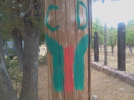
Camino marker in Pitorreal
Sandy wash leaving Pitorreal
The trail passes through the town approaching the railroad and taking a south-southwest direction. After intersecting with the railroad it turns right along the track (5 meters away on the left). After 50 meters in a sandy wash alongside a fence (on the right), the Camino bends right up a small hill into trees.
The Camino goes through a barbed wire gate and then continues downhill through the pine forest. It crosses a larger road that leads to a large structure on left. After 75 meters the trail reaches another wire gate on the left gate, turns hard right, and then continues along the fence for 150 meters until reaching the corner.
Visible from the Camino but 50 meters away on the left is a small Tarahumara cemetery, which may be decorated with colorful offerings. Hikers should treat the location with all due respect.
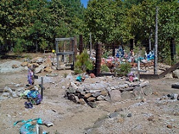
Tarahumara cemetery
segment_9.description.text_06
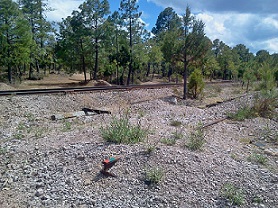
Las Quebredoras tracks
Las Quebredoras was formerly a station for the train, but is now nothing more than a wide flat area with abandoned rails (“double tracks”) in a gravel pit. At 1.9 kilometers, the Camino bends left to cross the tracks, both the abandoned rails and those still in use.
The trail continues close to the tracks that are on the right side (3 to 5 meters) for another 150 meters. At 2.0 kilometers from the start of this section, the trail bends left from the railroad and enters the forest. It descends into a short section with the railroad on the right and 10 meters above. After 250 in the trees the trail ascends to meet the tracks once again.
At this junction hikers can easily see one of the many tunnels used by the railroad – on the left roughly 50 meters away. Hikers turn left (toward the tunnel) and walk cautiously along the track for approximately 40 meters. Immediately to the left of tunnel is a narrow trail that rises steeply through the trees with switchbacks roughly 50 meters to a mid-level clearing near Highway 77.
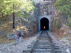
Trail to left of tunnel
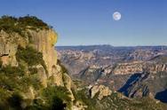
At the top of the trail there are good views to the left over various canyons to the East and North. The Camino does not cross 77. Instead, it bends left and follows a wide path 10 meters from the highway through low bushes. The highway is on the right and rising above the Camino.
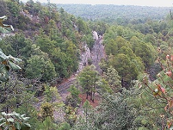
View of El Chepe below
This wide path becomes a road and continues for 400 meters, making a wide left turn through low trees and bushes with occasional views over the railroad below.
After 400 meters there is a narrow forest trail (smaller than the wide road that the hikers have been using) that rises steeply on the right and up the slope. The trail is narrow, and there are a few areas where it rises steeply over rocks and through the trees. Hikers must be careful to maintain their footing.
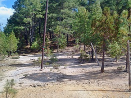
After 100 meters it reaches the top of the mesa. At the top of the mesa the Camino follows a forest path for 200 meters, then joining a wide dirt road that wanders through the woods. There are many paths leading in all directions in this area. Hikers should take care to remain on the larger dirt road.
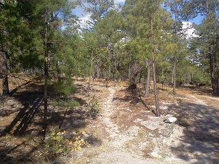
Forest path on the mesa
The wide dirt road goes all the way to a maintained and sign-posted country road leading from Highway 77 to the village of San Luis de Majimachi. (Hikers wanting to leave the trail and catch the bus may continue down this road to the bus stop.) However, approximately 100 meters from 77 (easily audible and often visible) there is sharp left turn into trees and onto up-and-down path. It passes a Tarahumara structure made of logs and then some Tarahumara fields. It passes between two fences until it reaches the Majimachi road. (The Majimachi access road is relatively wide and well-maintained.) The Camino turns sharply left onto the Majimachi road for 20 meters and then turns hard right into the forest again.
The forest path is easily followed and smooth, gradually curving to the right (toward Highway 77) through the trees. After 500 meters it passes (at a distance) some Tarahumara fields on the right. The trail remains in the forest but joins a small Tarahumara field along the fence line. After 100 meters along the fence, the Camino re-enters the forest briefly until reaching a junction with a wider forest road. The path turns right 90 degrees and continues in the trees past fields and fences until intersecting the new natural gas pipeline.
Immediately after crossing the cleared pipeline route, the trail makes a hard left turn past an area of small newly planted (2016) pine trees and heads downhill parallel to the gas pipeline. On the right are larger pine trees of the forest. After 50 meters the trail bends right into trees. In only 20 meters there is another right turn right onto a flat and smooth forest path that leads 400 meters to Highway 77.
However, the Camino does not cross the highway. Instead, it makes a near-180 degree turn to the left back along the trees to an isolated Tarahumara house with a small orchard on the left, Before entering the property, the Camino makes a sharp right turn onto a narrow forest path and descends 15 meters to a clearing which is immediately next to the railroad (now on the left). Directly ahead is a wide road parallel to the tracks (only 10 meters to the left).
The wide road continues 150 meters to where Highway 77 crosses the railroad. Across the highway is a small green and white shelter for individuals (largely Tarahumara living in the area) waiting for transport.
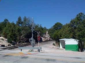
Bus shelter at crossing
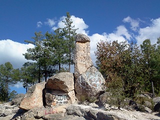
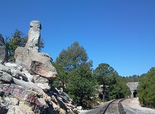
This crossing is well-known for its access to Fertility Rock (Piedra de Fertilidad), a phallic rock formation only 75 meters from the crossing on the left side of the railroad. Camino hikers should cross the highway and continue alongside the railroad on the right side of the tracks for 50 meters. There is extensive graffiti on the Rock itself, which looms 10 meters above the tracks and the Camino.
Fertility Rock
From the Rock the tracks make a very gentle bend to the right and enter into another tunnel. The tunnel is easily visible from the Rock, approximately 250 meters away.
However, twenty (20) meters past the Rock, the Camino turns left to cross the tracks. On the left there is a traditional rural path over tocks and past other impressive rock formations. Because the large flat rocks in this area prevent a visible trail in the earth, hikers must be careful to follow the Camino markers painted on smaller standing rocks. The Camino enters a nearly hidden break in the large rocks.
Fertility Rock tunnel
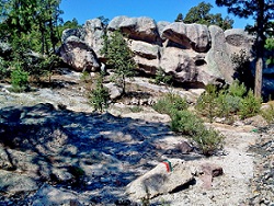
Markers on large rocks
After 50 meters through trees and rocks, the trail reaches the top of the mesa (approximately 10 meters of elevation change) roughly where the trail rejoins Highway 77. From this point the Camino continues alongside the highway in a long (100 meters), wide, flat area for vehicles. The trees to the right are roughly 20 meters from the highway.
Hikers pass a small religious shrine (painted green) approximately 75 meters into the sandy access area after leaving the forested area at the top of the mesa.
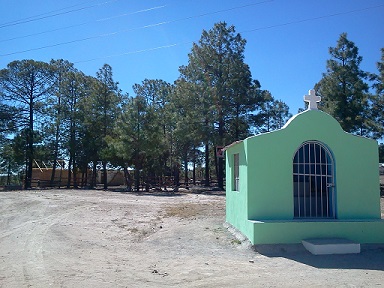
Nacayvo shrine
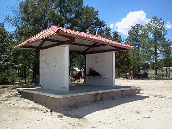
Nacaybo bus shelter
Beyond the shrine is a small white structure with a red roof. It is the Nacayvo bus stop. The bus shelter is located on the western edge of the highway access area next to the trees. It is the final destination for this Section.9.
Hikers wanting to cut short their excursion can catch a bus toward either Creel (32 kilometers north) or Divisadero (12 kilometers south).