Segment 5: From the Pipeline to San Elias
| Segment length |
3.52 km |
| Maximum elevation |
2477 m |
| Minimum elevation |
2414 m |
[2439.717711,2439.542159,2439.439267,2440.467828,2440.955804,2441.693205,2442.182362,2442.87448,2443.573527,2444.225783,2445.465142,2445.442773,2446.268605,2446.49934,2447.687828,2447.382152,2447.719513,2448.437915,2448.727859,2449.484202,2449.963879,2450.446292,2451.06718,2452.15277,2452.528133,2452.842765,2452.733331,2452.997993,2454.086781,2454.190954,2454.807887,2454.680052,2455.28955,2454.795334,2455.184991,2455.680718,2455.677576,2456.395297,2456.256383,2456.302185,2456.653987,2456.840528,2457.269567,2457.417431,2458.262974,2458.563233,2459.203586,2459.804783,2459.921818,2460.187593,2460.516399,2460.915885,2461.058636,2461.174717,2461.254667,2461.763813,2462.088192,2462.439324,2462.624971,2462.762251,2463.069266,2463.071982,2463.33184,2463.235612,2462.860702,2462.739318,2462.48696,2462.702957,2462.327639,2462.502404,2462.787971,2462.239923,2461.960599,2461.521826,2460.90239,2460.774011,2460.294613,2460.832519,2460.285085,2459.991845,2459.912721,2459.749164,2459.482832,2458.793171,2459.019504,2458.792692,2458.651866,2458.896978,2458.910863,2459.4374,2459.340665,2459.693176,2459.73688,2460.21105,2460.12242,2460.517259,2460.198924,2460.363669,2460.121272,2459.817578,2460.114034,2459.742509,2460.182786,2468.901179,2468.925384,2468.836571,2468.981599,2468.833965,2468.815909,2469.010751,2469.321305,2469.199495,2469.588705,2469.336982,2469.56059,2469.567721,2469.586749,2469.609415,2469.434555,2469.881216,2470.196846,2470.165578,2469.652461,2469.462218,2469.038979,2468.737161,2468.737639,2468.727657,2469.38185,2469.526723,2469.444788,2469.984127,2470.681414,2470.320667,2470.994696,2471.480128,2471.539037,2471.567546,2471.984855,2472.170754,2472.094015,2472.482043,2472.552549,2472.45752,2472.409247,2472.378781,2472.542646,2473.168655,2472.813037,2472.735574,2473.12078,2473.167321,2473.35691,2473.215001,2473.128913,2473.578936,2473.411367,2473.558102,2473.160423,2473.300019,2472.5843,2472.390783,2471.938917,2471.585877,2471.293198,2471.00074,2471.003539,2471.463637,2472.052164,2472.177293,2472.515322,2472.98078,2473.463493,2473.487493,2473.907635,2474.424625,2475.05989,2475.376526,2475.622916,2476.507227,2477.235856,2477.554654,2477.933866,2478.363716,2479.093967,2479.389283,2479.908389,2480.359669,2481.197768,2481.488774,2482.141001,2482.677611,2483.345932,2484.246247,2484.324362,2484.764774,2485.058166,2485.119389,2485.585352,2486.197353,2486.282403,2486.737165,2487.153031,2487.23325,2487.728043,2488.391959,2488.765165,2489.448908,2490.132228,2490.384969,2490.928542,2490.993647,2491.179936,2491.528748,2491.804043,2491.552327,2491.580005,2491.775028,2491.362204,2491.510633,2491.28288,2491.245186,2491.261293,2490.705747,2490.695403,2490.108257,2490.197385,2490.303519,2490.108055,2489.98528,2490.393847,2489.619704,2489.319619,2489.352475,2489.371246,2488.973637,2488.987003,2488.782159,2488.322546,2487.776835,2487.070304,2485.98668,2486.24202,2485.694429,2485.367966,2485.462851,2484.844221,2484.996021,2484.677726,2484.480561,2484.259743,2483.413874,2483.433528,2482.946725,2482.962384,2482.738948,2482.678459,2481.896554,2481.724772,2480.741242,2480.348646,2479.144163,2479.687996,2479.159249,2478.757456,2477.872638,2477.974374,2477.914771,2477.415545,2477.079739,2476.602062,2476.827046,2476.489963,2476.649223,2475.896826,2475.330995,2475.462202,2475.184111,2474.699675,2475.032803,2474.88803,2474.534557,2474.657889,2474.905378,2475.255205,2475.057556,2474.756283,2474.421562,2474.009333,2473.67456,2473.180042,2472.948935,2472.768424,2472.66138,2472.295025,2472.395123,2472.639534,2472.491608,2472.297164,2471.584295,2471.212375,2470.874368,2470.595561,2470.406572,2470.024056,2469.15369,2469.045663,2468.572524,2467.993725,2467.146712,2466.791437,2466.402575,2465.925905,2466.17732,2465.931808,2465.636685,2465.424516,2464.837012,2465.109104,2465.256507,2465.020683,2465.244276,2464.578834,2464.219588,2464.324421,2463.962385,2463.944488,2463.836646,2463.588373,2464.128643,2463.821773,2463.530644,2463.376405,2462.948562,2462.50193,2462.506012,2461.832148,2461.109732,2460.609149,2460.367643,2460.034533,2460.165526,2459.954238,2459.700129,2459.274176,2459.02196,2458.799457,2457.692867,2456.707563,2455.909316,2455.608767,2455.714445,2455.617546,2454.849258,2454.648858,2454.614215,2454.170333,2453.317373,2453.063429,2453.703518,2453.123161,2452.634479,2452.245807,2452.050474,2451.98382,2451.893327,2451.713615,2451.437081,2451.601894,2451.907404,2451.3186,2451.316483,2450.993954,2450.973169,2450.809287,2450.871384,2450.714814,2450.410908,2450.385664,2450.463499,2450.177883,2449.880138,2449.483007,2449.14072,2448.933577,2448.621276,2447.802472,2447.360861,2447.020249,2446.443796,2446.213903,2445.934924,2445.734437,2445.109536,2444.722657,2444.721365,2444.242535,2444.014259,2443.230102,2442.916512,2442.277185,2442.042335,2442.04378,2442.031674,2441.501009,2441.457928,2441.082367,2440.744669,2440.625562,2440.385111,2439.929735,2439.591089,2439.645634,2439.450717,2439.097793,2438.810189,2438.954908,2438.698564,2438.744983,2438.316808,2438.042259,2437.367377,2437.390519,2437.104645,2436.30235,2435.938836,2435.665416,2435.087572,2434.900023,2434.831102,2434.910904,2434.371258,2433.982254,2433.682761,2433.07978,2433.058422,2432.584677,2432.412267,2431.831411,2431.386604,2430.810199,2430.015285,2429.56087,2429.744838,2430.238753,2429.763767,2429.674415,2429.886883,2428.9871,2428.620163,2428.179211,2428.376087,2428.486928,2428.629954,2428.202502,2428.06533,2427.55862,2427.725385,2427.858714,2427.629863,2427.660311,2427.726795,2427.752778,2427.467862,2427.604473,2427.377707,2427.568223,2427.336261,2427.566959,2427.65906,2427.920816,2428.189377,2428.43533,2429.078725,2429.457983,2429.62406,2429.686981,2429.842235,2429.782012,2430.340203,2430.448949,2430.516919,2430.809206,2430.915109,2430.934566,2431.116516,2431.288084,2431.113066,2431.430174,2431.532371,2432.122672,2432.368795,2432.896027,2433.414333,2433.618518,2433.745034,2433.04447,2433.812031,2433.731234,2433.873022,2434.095694,2433.9159,2434.855575,2435.663235,2436.376161,2436.427941,2437.059125,2437.4754,2437.817857,2438.015882,2438.022973,2437.959793,2438.038372,2438.019077,2438.105709,2438.081417,2438.725587,2439.065786,2438.961217,2438.762541,2439.061063,2438.978174,2439.414638,2439.560828,2439.39038,2439.224156,2439.416571,2439.508471,2439.154917,2439.697383,2440.208795,2440.435742,2440.317716,2440.406196,2440.326064,2440.52416,2440.440425,2440.886189,2441.405192,2441.565664,2442.292765,2441.788422,2440.990902,2441.632129,2441.5948,2441.810389,2442.5641,2442.400617,2442.963778,2443.093269,2442.68938,2442.926851,2443.118632,2443.474629,2443.861308,2443.588316,2443.639458,2443.903701,2444.307364,2444.144975,2444.235242,2444.515605,2444.965881,2445.086432,2445.405948,2445.357881,2445.141384,2445.244886,2445.452652,2446.00287,2446.269783,2446.254718,2446.350244,2446.546485,2446.818668,2446.854126,2447.190939,2447.233275,2447.475572,2447.35141,2447.473714,2447.888265,2447.880646,2448.073587,2447.996404,2448.187542,2448.246,2441.633232,2438.683932,2439.045918,2439.434866,2439.73061,2439.280127,2439.288436,2439.509846,2439.78312,2439.522241,2439.576041,2439.842672,2440.027718,2439.309823,2438.737854,2438.306076,2438.087994,2439.035915,2439.291969,2439.279592,2438.688377,2438.367182,2439.062314,2438.337704,2438.68141,2439.096409,2439.162447,2439.400599,2439.535912,2439.626183,2439.817174,2439.696718,2439.569448,2439.896827,2440.188178,2440.265362,2440.355384,2439.956742,2439.30769,2438.786712,2438.269536,2438.429115,2438.772407,2438.932519,2439.50089,2440.31436,2440.671053,2440.596174,2440.853093,2441.716066,2442.486251,2442.88167,2443.676889,2443.807131,2444.222169,2444.09905,2444.362264,2444.777611,2444.642987,2445.690883,2445.550287,2445.660772,2445.660265,2445.782506,2445.520967,2444.691034,2444.395042,2444.152214,2444.199713,2443.871669,2444.110295,2444.16103,2444.029647,2444.200974,2444.822028,2445.382428,2445.423526,2444.964914,2445.155574,2444.979447,2444.918911,2445.100495,2445.814628,2445.913058,2446.272654,2446.638299,2447.062321,2446.896304,2447.495649,2447.633587,2447.888483,2447.826588,2448.301314,2448.061338,2448.034958,2447.861629,2447.730947,2447.774311,2447.74546,2447.577317,2447.087329,2447.146171,2446.98262,2446.626027,2446.40079,2446.337636,2446.267426,2445.654642,2445.062333,2444.537468,2444.117197,2443.101604,2442.559868,2442.303494,2442.18449,2442.171035,2442.341606,2443.272354,2443.919004,2444.238579,2445.090888,2445.221237,2445.612946,2446.670859,2446.910903,2447.664784,2447.961339,2448.182587,2448.53562,2448.700851,2449.174981,2449.411336,2449.716958,2449.697292,2449.594645,2449.918356,2450.38437,2450.551734,2450.167805,2450.03755,2450.359739,2450.49345,2450.828482,2450.324119,2450.000971,2449.864903,2449.896492,2449.694356,2449.694229,2449.628249,2449.460443,2449.558,2449.246927,2449.125136,2448.984787,2448.771355,2448.889448,2448.613976,2448.622689,2448.549969,2448.235243,2447.872975,2447.47153,2447.034948,2446.711301,2446.464033,2445.915396,2445.468909,2445.138102,2444.867193,2444.293368,2443.909028,2443.619165,2443.313186,2443.249364,2442.580878,2442.633467,2442.68147,2442.309005,2441.949969,2442.044456,2441.670219,2441.286647,2441.025726,2440.838905,2440.10152,2439.471278,2439.117355,2439.186605,2438.897392,2438.763777,2438.912833,2438.758464,2438.515591,2438.143275,2437.822453,2437.719219,2437.911464,2438.763195,2438.849393,2438.778906,2438.282127,2438.051555,2437.999271,2437.696388,2437.406542,2436.918776,2436.481467,2436.52491,2435.679344,2435.40044,2435.677716,2435.335695,2435.715501,2435.926711,2436.064729,2436.104214,2436.165335,2435.560948,2436.164668,2435.609631,2436.173484,2436.178093,2436.46437,2436.70903,2436.305813,2436.319322,2436.425698,2436.519833,2436.550783,2436.729909,2438.045268,2438.166223,2437.756932,2437.933215,2437.877769,2438.3209,2438.650888,2439.71091,2440.370891,2440.690931,2441.472105,2441.35036,2442.514965,2442.929534,2444.217781,2444.332839,2444.690242,2444.827125,2445.22426,2445.532247,2445.576919,2445.556384,2446.248325,2446.867229,2447.459012,2447.658375,2448.607184,2448.550139,2449.437974,2449.720905,2450.738754,2451.287921,2451.670248,2452.008064,2452.627271,2452.854185,2453.478622,2453.817279,2453.990382,2454.06642,2454.53562,2455.174403,2455.13044,2455.597993,2455.393403,2455.906873,2456.215898,2456.450765,2456.497563,2456.942818,2456.571599,2456.807109,2456.880957,2457.165467,2457.0276,2456.955568,2457.044509,2457.30717,2457.61599,2458.229361,2458.398068,2458.440805,2459.079658,2459.029302,2458.723682,2458.068105,2458.263951,2458.391872,2458.513363,2458.479185,2459.244127,2459.167438,2458.815589,2458.264589,2458.358705,2459.320222,2458.549747,2458.570134,2459.088105,2458.501207,2457.718282,2458.282316,2458.062864,2458.237122,2458.338273,2458.524129,2458.565816,2458.529966,2458.565061,2458.446623,2458.527249,2458.361744,2458.596446,2458.467934,2458.19621,2458.313353,2458.42812,2458.340229,2458.451767,2458.208533,2457.934776,2457.807563,2457.584361,2457.507677,2457.466916,2458.077733,2458.261338,2458.678765,2458.378302,2457.89698,2458.429295,2458.593906,2458.483725,2458.589132,2458.23136,2458.231611,2458.027922,2457.806127,2458.043389,2458.733581,2458.629669,2458.492044,2459.079959,2460.5359,2459.301846,2459.280731,2459.139166,2459.445614,2459.311504]
Overview
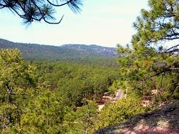
This section of the Camino goes ~3 km southwest from the crossing point of the gas pipeline and the small community of San Elias. Much of the trail is a pleasant walk through pine forest near the community of El Ojito located on the Creel-Divisadero highway. The trail lies between the highway (east) and the railroad (west). Although often not in sight of the highway or railroad, it is sufficiently near that train and road traffic can be heard. A highlight of the section is crossing the railroad at the point where the railroad itself crosses under the Highway 77 bridge.
Trail description
After leaving the cleared pipeline area, the trail again follows the course of the gas line up a small hill and then generally flat for 600 meters. Trail markers often are painted on large rocks in the path. At the start both the tracks (on the right) and the road (on the left) run near the trail in cut-out courses ~5 - 10 meters below the trail. The railroad then bends farther away from the trail to the right (turning northwest).
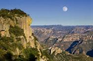
At 600 meters the trail comes to the top of a hill and turns sharply to the right away from the pipeline. The highway is visible from this highpoint to the front, and there are views to the left over rolling barranca country. After the sharp turn the trail turns back to the left, descending slightly through the trees. It then climbs steeply (up 10 meters in 50 meters) a short hill through the forest. From the hill top there are more views to the left from large boulders on the rim.
View from Boulders
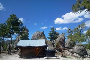
The trail crosses low vegetation to the left and joins a defined single track path through the woods, gradually descending and bending left. The path is through the pine and madrone forest. After ~200 meters it bends gently to the right while continuing to descend. The railroad is ~1/2 km to the right at this point. As the trail approaches the dispersed community of El Ojito, there are a number of paths and roads connecting the Tarahumara families who often live near the rocks scattered throughout the area. Care to follow the Camino markers (primarily on trees) may be necessary.
After ~1 km the trail reaches the bottom of the El Ojito valley the trail crosses the valley in sight of various farm fields along fences. At the corner of one such farm (~150 meters into the valley), the trail turns right onto a rural road and climbs gradually along a network of rural roads to where it approaches the railroad (after 1/2 km). The road is wide enough for vehicles and passes through the pine forest with frequent shady sections. Care to follow the Camino markers on both trees and rocks may be necessary.
Tarahumara House in the Rocks
Road Near Train Tracks
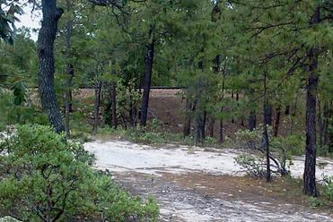
Near the close approach of the railroad (amid a large boulder field), a small field and Tarahumara dwellings are visible on the left. The trail continues through the trees generally flat for 300 meters until leaving the road and bending right onto a narrow single track path through the forest. Care to follow the Camino onto this narrow path may be necessary. Within ~30 meters the path crosses a water course before continuing flat through the trees. Another ~300 meters further on, the trail turns right onto a wider path / road and descends slightly while later bending left.
After ~250 meters the Divisadero highway becomes visible on the left. In addition, the railroad is also getting closer to the trail from the right. The trail leaves the road turning right onto a narrow path that passes through low bushes toward the highway as well as the railroad.
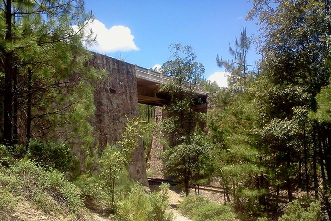
Highway Bridge Over Railroad
After ~100 meters the path crosses the railroad at the point where the tracks pass under the highway (a 10 meter high stone and steel bridge). (27.690123, 107.720119, elevation 2442 meters). It again passes through slow vegetation while gradually climbing ~10 meters in the trees along a defined path across a barbed wire fence. ~100 meters past the fence the path bends left to merge with a rural road. The trail continues 150 meters along the road through the forest to the community of San Elias.
San Elias is a small Tarahumara community with a number of buildings scattered across an open area of fields and houses. It is just on the right (west) side of the Creel-Divisadero highway. The trail enters the village by turning right onto the highway access road next to a distinctive green and white 15 meter high water tower (27.687397, 107.724006, elevation 2453 meters). Further along the access road is a small white church and many other buildings.
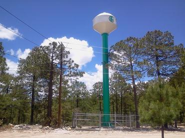
San Elias Water Tower