Segment 4: From Recowata Road to the Pipeline
| Segment length |
2.67 km |
| Maximum elevation |
2471 m |
| Minimum elevation |
2414 m |
[2449.042213,2449.448263,2450.188461,2448.639732,2448.984945,2448.938814,2449.022524,2448.704212,2448.872693,2448.218289,2448.840342,2448.268059,2448.167704,2448.287497,2448.12108,2447.892724,2447.815661,2446.960295,2447.278284,2446.629104,2446.624699,2446.646906,2446.210474,2446.561924,2446.510192,2447.071347,2446.312231,2445.892137,2445.321076,2444.996093,2444.477306,2443.80342,2442.899732,2442.985604,2442.900359,2442.400312,2442.622361,2442.73943,2442.366261,2441.82539,2441.868562,2442.041796,2441.99062,2441.925016,2441.932464,2441.635881,2441.394588,2441.253117,2441.200782,2440.767938,2440.727531,2440.647643,2440.299692,2439.598032,2439.665721,2439.02988,2439.115661,2439.698765,2439.627503,2440.762472,2440.581446,2440.539365,2440.896608,2441.167962,2441.93717,2442.451384,2442.289306,2442.5282,2442.814647,2442.73895,2442.611815,2443.327296,2443.305012,2443.529111,2443.698949,2443.604194,2443.744866,2443.715051,2443.533874,2443.452853,2442.921466,2442.368384,2442.182558,2442.118469,2442.504043,2442.391478,2442.471973,2442.963976,2443.035463,2442.840953,2442.423804,2442.319718,2442.876862,2442.674377,2442.526667,2442.920146,2442.827553,2442.578539,2443.11728,2443.580638,2443.332972,2443.598304,2443.655784,2443.293783,2443.153172,2442.947695,2442.737759,2442.028135,2441.170827,2441.141857,2440.413278,2439.583133,2438.90294,2438.35212,2438.20806,2438.001992,2437.891001,2438.055842,2438.43222,2438.27182,2438.734921,2438.14277,2437.978515,2437.912994,2438.027734,2438.574784,2438.571324,2438.39637,2439.165112,2438.937743,2439.503061,2439.521836,2440.102412,2440.490519,2441.015926,2441.28121,2441.353904,2441.697534,2442.076789,2442.026588,2442.644984,2443.201287,2443.122603,2443.385084,2444.530159,2444.79343,2445.125696,2445.456406,2445.717887,2446.646941,2446.732289,2447.704187,2447.669313,2448.236065,2448.470621,2448.554095,2448.589665,2448.741406,2449.196082,2449.535826,2449.62526,2449.780141,2450.016582,2449.350469,2448.139112,2447.447871,2447.082826,2446.861088,2446.748642,2446.726682,2446.304623,2446.197913,2445.926863,2445.865288,2445.346053,2445.213823,2444.789478,2444.313231,2443.762177,2443.049861,2442.462065,2441.615048,2440.989008,2440.561273,2440.191804,2439.877304,2439.03346,2438.619048,2437.947015,2437.349148,2436.91467,2436.599245,2435.868647,2435.769915,2435.274017,2434.633811,2434.036876,2433.132228,2432.578813,2432.136284,2431.445759,2430.645131,2430.111431,2429.731735,2428.601941,2428.677022,2428.85621,2428.995846,2429.27838,2429.545478,2429.88744,2429.810752,2429.682031,2429.234401,2428.789255,2428.876969,2428.916136,2428.750466,2428.667784,2429.008559,2429.314976,2429.386314,2429.601471,2429.693216,2429.799232,2430.16218,2430.678043,2431.057317,2431.273704,2431.775596,2431.986463,2432.033508,2432.551241,2432.998394,2432.917121,2433.51899,2434.1367,2433.754498,2434.739415,2434.613184,2435.46882,2435.674069,2436.078773,2435.829973,2436.114361,2436.578776,2436.513141,2436.80098,2437.056891,2437.243108,2437.545685,2437.619187,2437.715408,2437.895302,2437.850549,2438.348711,2438.4246,2438.738076,2438.886102,2439.760624,2439.807584,2440.28079,2440.435383,2440.298562,2440.866203,2441.031988,2441.369481,2442.008266,2442.509021,2442.329527,2442.453775,2442.682665,2442.855209,2443.284122,2443.770826,2443.705884,2444.2396,2444.329577,2444.672711,2445.022081,2444.906816,2445.989027,2446.209957,2446.238976,2446.1827,2446.436619,2446.446307,2447.801818,2448.203309,2447.951381,2447.957504,2448.235055,2448.827196,2448.326788,2450.056039,2449.92422,2450.175176,2450.348326,2450.746038,2450.892839,2451.546867,2451.618179,2451.89172,2451.974491,2452.2417,2452.469504,2452.746,2453.129935,2452.86568,2452.816738,2452.381262,2452.376298,2452.484006,2453.162743,2452.991144,2452.818469,2453.29697,2453.428222,2453.543071,2453.228218,2452.906457,2453.483975,2453.898863,2454.562655,2454.656189,2454.481309,2454.492186,2454.615059,2454.749043,2454.93387,2455.202548,2454.843412,2454.851433,2455.024274,2455.272257,2455.245706,2455.669942,2455.671582,2455.561314,2455.303266,2455.557486,2455.211612,2455.202316,2455.138442,2454.993619,2454.925868,2454.743646,2454.714119,2454.580923,2454.239812,2454.47861,2454.20415,2453.972986,2454.427121,2454.143451,2454.936425,2454.644048,2454.126866,2454.275362,2454.176308,2454.523051,2454.566274,2454.334923,2454.052368,2457.897922,2459.035649,2459.156321,2458.986403,2459.54657,2459.109827,2459.569657,2459.308859,2459.165463,2458.977971,2458.444593,2458.43282,2458.393949,2458.840847,2458.694119,2458.775192,2458.726094,2458.893532,2459.301019,2459.358029,2459.309653,2459.224384,2459.130431,2459.25789,2459.564283,2459.564288,2459.296904,2459.225191,2459.571947,2459.890295,2460.582727,2460.236264,2460.442013,2460.535343,2460.9701,2461.156628,2461.134506,2461.647621,2461.918146,2462.297686,2462.262567,2462.667295,2463.118536,2463.027172,2463.43441,2464.01824,2463.99567,2464.287549,2464.410495,2464.890206,2465.24352,2465.419332,2465.81122,2466.236177,2466.357679,2466.151442,2466.797226,2467.065141,2467.672339,2468.212191,2468.494644,2468.837181,2468.788497,2469.00955,2469.706103,2469.805507,2469.920596,2470.328058,2470.642521,2470.899445,2471.075129,2471.273448,2471.56094,2471.742684,2472.098325,2472.189325,2472.466852,2473.107205,2473.290834,2473.045021,2473.669328,2473.77742,2473.65971,2473.72857,2473.704801,2473.814807,2473.242292,2473.076674,2473.004581,2473.215412,2472.504164,2471.932907,2471.518169,2470.888663,2470.490274,2470.305793,2470.256148,2470.009929,2469.684099,2469.343617,2468.500815,2468.08765,2467.650126,2467.310672,2466.921412,2466.462913,2465.554936,2465.599503,2465.08748,2464.150581,2463.327455,2462.714052,2462.196494,2460.623889,2459.98565,2459.185743,2458.740103,2458.60478,2458.349367,2458.48944,2458.808025,2458.936381,2458.873069,2458.761563,2458.725807,2458.173651,2457.884545,2457.392077,2456.883954,2456.390564,2456.436045,2456.522571,2456.09093,2455.653167,2455.293124,2454.903127,2454.604007,2454.184554,2453.749158,2453.563234,2452.711219,2452.743045,2452.612005,2451.478776,2450.761193,2449.959108,2449.820519,2449.203995,2448.648117,2448.425209,2447.803456,2447.135504,2446.58539,2446.31344,2446.049007,2445.64283,2445.010519,2444.775932,2444.415309,2443.585708,2443.151278,2443.070094,2442.834897,2442.231347,2441.871277,2441.464222,2440.965267,2440.631133,2440.098943,2439.401006,2439.121731,2438.273081,2438.107135,2437.932115,2438.068112,2437.983964,2438.758398,2439.385219,2439.90353,2440.309312,2440.832118,2441.330275,2441.983747,2441.877802,2442.112392,2442.498293,2442.367207,2442.552545,2442.47915,2442.799264,2442.745277,2442.502013,2442.549552,2442.111194,2441.741664,2441.462379,2440.700783,2440.826224,2440.5031,2439.436143,2439.092006,2438.37317,2438.087809,2437.50701,2437.364759,2436.944752,2436.293201,2435.50275,2435.071504,2434.19379,2433.856288,2433.194258,2432.998675,2432.720167,2432.203441,2431.780933,2431.257183,2430.730982,2430.891441,2430.234555,2429.912344,2429.547496,2429.042872,2428.260507,2427.621749,2428.079747,2427.720654,2427.875163,2427.724598,2427.739845,2427.16822,2426.894366,2426.676539,2426.185644,2426.008218,2425.336059,2424.547308,2424.325293,2423.877542,2423.793109,2423.245097,2422.610321,2422.470749,2422.275288,2421.88471,2421.582062,2421.788293,2421.583549,2421.117919,2420.786424,2421.245128,2420.786443,2420.58584,2420.273059,2420.270004,2420.390566,2420.203878,2420.419304,2420.717042,2420.574233,2420.581007,2420.774223,2420.354983,2419.992151,2419.53899,2418.824337,2418.507793,2418.007676,2417.447395,2416.986719,2416.63412,2416.783556,2415.943146,2415.455004,2415.363214,2414.790603,2414.736245,2414.810014,2414.835954,2415.040553,2415.565038,2415.912913,2415.761543,2415.878383,2416.083756,2416.401014,2416.951012,2417.091268,2417.182941,2417.340906,2417.190018,2417.59747,2417.791976,2418.22541,2418.401392,2418.607619,2418.700404,2419.382144,2419.588215,2420.145092,2420.427053,2421.024668,2421.213399,2421.508037,2421.582584,2421.558221,2421.272967,2420.933607,2421.075123,2421.074652,2420.396242,2420.357086,2420.347223,2420.022719,2420.086525,2420.131052,2419.828459,2419.54327,2419.712154,2419.050011,2419.162134,2418.76365,2418.731465,2418.427377,2418.504251,2418.25843,2418.91717,2418.927879,2419.320337,2419.661176,2419.966924,2420.225912,2420.676109,2421.020991,2421.205275,2421.65586,2422.112808,2422.538993,2422.59613,2423.180078,2423.49614,2423.88498,2424.401911,2424.386373,2424.810161,2424.989283,2425.252424,2426.208656,2425.928676,2426.403035,2427.070377,2427.136755,2427.584532,2427.646274,2423.750034,2422.650579,2422.794997,2422.876863,2423.292714,2423.349943,2423.487109,2424.153548,2424.132602,2424.726197,2424.52975,2425.169123,2425.844706,2426.1523,2426.489858,2427.561432,2428.661592,2429.938182,2430.75474,2430.96744,2431.220794,2430.875712,2431.231179,2431.609328,2432.323604,2432.441651,2432.700832,2433.111489,2433.167921,2433.985224,2434.408207,2434.720357,2435.146766,2435.24234,2435.59869,2435.947516,2436.41519,2436.560382,2437.10321,2437.260926,2437.388138,2437.864587,2437.880739,2438.375139,2438.014331]
Overview
This section of the Camino travels 2.5 kms from the turnoff to the Recowata thermal baths to the crossing of the Creel gas pipeline under the Divisadero highway. It follows the buried course of the pipeline between Creel and the Pacific Coast ports (generally toward the southwest). As of 2015, the area cleared for the burial of the pipeline had not regrown and was lined with dirt and rocks displaced during pipeline construction. The course is wide (~8 meters) and easy to follow. Any short sections of the Camino on smaller paths typically rejoin the pipeline course in ~100 meters. Occasionally the pipeline itself (~ 30 centimeters in diameter and red in color) is visible above ground. The pipeline and the Camino remain near the Divisadero highway (varying up to 50 meters away) for the entire length of this section. However, shortly after Recowata, the railroad turns more directly west and separates from the Highway.
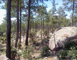
Boulder Fields
The walking path is often over exposed rough rocky terrain with only low vegetation and few trees. However, there are also short sections within the pine forest (which is generally to the left of the trail) through large boulder fields. There are several water courses or gullies or rolling terrain to cross with a final descent of ~50 meters in the last 500 meters.
Trail description
The trail starts on the south edge of the Recowata parking area, overlooking a large "balancing" boulder. From the parking lot it joins a road that descends slightly to the beginning of the cleared pipeline course. The Divisadero highway is on the right less than 30 meters away. The trail goes up and down slightly for the next ~500 meters with markers painted on the numerous large rocks buried in the road or on the side. After ~500 meters the path enters a small clearing near the highway, passing near a concrete valve box for the pipeline.
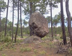
Balancing Rock
The trail continues through the clearing to a dirt road to the south west that descends sharply into a gully alongside the pipeline that is above ground at this point. The path bends to the right through the trees while the pipeline rises steeply above ground on the west (south) side of the gully. The trail climbs and bends back left toward the pipeline still visible. It then turns sharply right through very large boulders and climbs on a forest path toward the Divisadero highway. The highway remains only 30 meters to the right during this entire portion of the trail.
The path bends slightly left to avoid crossing the highway and climbs through the trees. At ~900 meters the path again enters a large clear area with another concrete valve box. (27.702436, 107.688838, elevation 2480 meters).
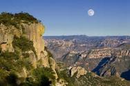
After crossing the clear area (under the wires of the power transmission line), the Camino bends left and follows the cleared pipeline route above and along the highway. At ~1.2 km the trail separates slightly from the pipeline and climbs a short hill through the trees to another clearing with somewhat restricted vistas of small canyons to the right. The highway remains 20 meters to the right.
From this highpoint the trail rejoins the pipeline course for its descent (slightly <1 km) to the crossing point of the pipeline and the highway. The railroad also rejoins the highway (coming from the right) at the bottom of the hill. The trail is on open ground as it drops alongside the highway on the right. As the highway bends right (more to the west), the pipeline and trail also turn to the right.
50 meters before the pipeline crosses under the highway, the trail turns left off the wide pipeline course onto a narrow single track path in the trees that leads to a small stream course. It makes a single switchback up the other side to join a rural road (turning left at the junction). It continues 75 meters skirting the hill that the highway is climbing to the right. After 75 meters the trail turns very sharply (more than 90 degrees) to the right and climbs steeply (up ~10 meters in 50 meters) to the point where it crosses the highway. Care to follow the Camino markers may be necessary.
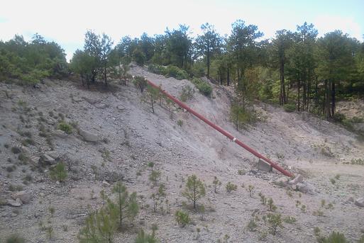
Pipeline
After crossing the highway, the trail turns to the left on a path through low trees to the top of the cleared area where the pipeline has also risen from its own crossing point below on the highway (27.694353, 107.695621, elevation 2451)). A 10 meter angled section of the red pipeline is clearly visible. From the clear area the railroad is also visible below. There are also more distant views of tree-covered canyons to the east. The upper level of the gravel pit is the starting point for the following Segment 5.