Segment 3: From Santa Elena to Recowata Turn-off
| Segment length |
1.48 km |
| Maximum elevation |
2460 m |
| Minimum elevation |
2448 m |
[2452.1051,2452.333217,2452.415617,2452.315185,2450.405433,2451.344334,2451.634073,2451.488295,2451.029024,2451.012263,2451.45242,2452.202567,2452.208259,2452.491433,2452.370338,2452.439291,2452.594912,2451.724139,2451.703094,2451.994948,2451.451129,2451.412313,2451.18059,2451.066621,2451.093124,2450.823204,2450.415921,2450.656531,2450.51101,2450.043096,2450.30463,2449.78859,2449.370057,2448.810545,2448.297838,2447.62051,2447.218436,2446.860769,2446.811504,2446.665172,2446.447474,2446.476245,2446.148862,2446.556176,2447.138505,2447.101692,2447.773192,2448.400848,2448.927385,2449.256186,2449.671573,2450.556125,2450.488569,2451.059195,2451.448744,2451.661524,2451.40056,2451.522289,2451.929683,2451.948542,2452.534495,2452.703403,2453.579621,2453.588379,2453.140201,2453.213324,2453.447308,2454.270874,2454.244149,2453.675269,2453.292107,2452.557302,2452.439185,2452.205364,2452.566245,2452.121166,2451.271137,2451.113412,2451.248955,2451.164035,2450.743834,2450.579955,2451.036536,2450.940105,2450.953456,2450.841396,2451.283766,2451.591357,2451.720687,2451.942224,2452.174873,2452.060444,2452.578383,2452.782207,2453.608633,2452.846037,2452.995566,2453.57129,2453.366738,2453.628304,2453.639457,2453.399684,2453.47173,2453.767852,2453.921511,2454.073364,2454.134548,2454.741256,2454.767187,2455.449133,2455.083281,2454.977014,2455.476687,2455.630605,2455.312114,2455.686657,2455.503821,2455.61239,2455.841543,2455.492185,2455.541863,2455.606398,2455.917222,2456.132011,2455.950289,2456.027008,2455.896159,2456.015516,2456.388023,2455.945809,2456.470164,2456.32193,2455.940008,2456.027573,2455.759126,2455.764629,2455.873429,2455.604288,2455.36468,2455.27363,2454.90106,2454.820793,2454.898361,2454.590662,2454.970416,2454.863523,2454.947305,2454.795509,2454.796122,2454.357935,2454.13026,2453.870358,2453.675994,2453.259092,2453.027114,2452.502167,2452.213946,2451.909872,2451.567735,2450.609984,2450.215996,2450.185597,2449.792088,2449.706665,2449.620803,2450.093827,2449.96474,2450.214419,2450.377891,2450.96137,2451.303204,2451.304966,2451.337676,2451.778589,2451.799662,2452.063803,2452.342194,2452.365308,2452.883793,2453.123872,2453.348938,2453.486944,2453.882548,2454.240973,2454.535233,2454.899769,2455.062485,2455.879051,2456.082293,2456.210403,2456.340359,2456.439175,2456.776196,2457.068155,2457.404042,2457.229848,2457.515376,2457.577611,2457.997312,2457.977639,2458.822012,2458.85421,2458.822414,2458.982771,2459.327596,2459.400216,2459.488491,2459.57983,2459.692851,2459.636528,2459.653975,2459.247601,2459.41571,2459.574903,2459.464451,2459.492684,2459.038338,2459.193868,2458.926823,2459.063193,2459.299863,2459.284257,2459.180692,2459.026367,2459.558608,2459.659938,2459.597177,2459.46656,2459.753372,2459.642516,2459.517804,2459.408645,2459.01475,2458.920301,2458.97556,2458.642189,2458.373294,2458.234233,2458.494846,2458.535178,2458.268332,2458.27613,2457.952886,2457.905857,2457.736722,2457.751366,2457.897213,2457.970168,2458.368526,2457.909127,2458.078009,2458.203915,2457.990422,2457.985454,2458.139754,2458.10868,2458.173744,2459.008706,2459.187141,2459.11353,2458.419637,2458.299289,2458.393303,2457.832238,2458.50351,2458.632576,2458.753403,2458.915559,2458.351056,2458.968448,2457.615486,2457.247854,2456.120116,2455.414347,2455.146516,2455.247361,2455.117104,2454.659348,2454.846399,2455.144358,2454.985757,2455.423182,2454.967231,2455.176167,2455.394662,2455.306118,2455.245121,2455.718977,2455.699945,2455.578678,2455.022283,2455.345444,2455.303672,2455.397729,2454.985382,2454.589233,2454.25977,2454.334169,2454.492583,2454.909976,2454.783381,2455.236516,2455.451616,2455.183247,2454.109154,2454.415115,2454.10031,2454.550618,2454.569184,2454.547449,2454.183068,2455.481909,2455.257862,2454.791848,2454.573069,2454.613235,2454.678894,2454.69548,2453.748441,2454.024929,2453.671304,2453.440537,2453.333091,2453.610728,2453.805563,2454.442078,2454.466247,2454.661929,2455.224108,2454.859157,2455.587993,2455.941153,2455.307273,2455.507336,2455.418014,2456.122217,2455.607389,2455.229125,2454.937589,2454.985678,2455.132612,2454.725899,2454.762058,2454.669179,2454.031446,2454.145865,2453.987563,2453.718264,2453.696222,2453.25225,2453.213127,2452.562682,2452.896525,2452.611595,2452.695505,2452.695569,2452.832316,2453.007445,2452.653086,2452.803175,2453.07417,2452.977186]
Overview
The short section of the trail connects the Santa Elena / Estación Sanchez area with the unpaved road leading to the well-known Rukiraso waterfall and Recowata thermal baths (“aguas termales”). It generally follows a good rural road that parallels the railroad tracks (between 20 to 40 meters to the left of the Camino). Often the trail goes through the pine forest with both shady and sunny portions. As a consequence the road is generally flat with only two slight and gradual water course crossings. The total distance is ~ 1.5 km.
Trail description
From the Sanchez / Elena bus stop and parking area, the trail crosses the railroad tracks onto a short section of rural road, turning a sharp left immediately after crossing the tracks. The railroad is still a double set of tracks at this crossing. In addition, the train sign for "Sanchez" is also visible on the east side of the tracks.
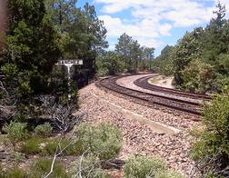
Sanchez Railroad Sign
After crossing, in ~15 meters the trail turns sharp right and then immediately (5 meters) left onto a good rural road that the trail follows for the next 1.5 kms. The railroad tracks are 10 - 15 meters on the left and generally visible. Further to the left (east) is the Divisadero highway also running parallel to the railroad. Hikers will also be able to hear the traffic from this highway. On the right is the pine forest,
The trail descends slightly in the next 50 meters but immediately rises to return to the flat terrain at the same level as the tracks. In ~300 meters there is a crossing with other unrelated roads, but the Camino continues straight on the rural road. (The left road - which turns back more than 90 degrees - goes closer to the tracks.). The railroad and the trail go south - southwest and straight for this entire section. In certain portions of the trail it passes through the shade of the pines. Markers are on trees and rocks in the road.
~1.2 kms along the trail the vegetation thins somewhat. The road comes to a fork, and the Camino takes the left path closer to the tracks. The trail is smaller than the right fork that passes through a fence and continues to the right (farther from the tracks) along a fence. The Camino is to the left (closer to the tracks and on the east side) of this fence. The tracks are close to the trail (5 to 10 meters) and easily visible.
The path passes through scattered low brush. At ~1.5 kms the trail crosses the tracks (single set of tracks). A small white cross (burial site) becomes visible. It crosses through more low brush for another 50 meters before reaching the Divisadero highway. It crosses the highway into the Recowata road and parking area.
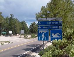
Recowata Road Sign
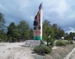
Recowata Sculpture
The Recowata turn-off (27.708892, 107.684341, elevation 2450 meters). is a large bare gravel area on the left (east) of the highway with large highway signs. The Recowata road itself turns left off the highway in the middle of the gravel area. A large blue sign indicates all the attractions along the road (viewpoint, baths.). In addition, there is a distinctive large white "sculpture" with several vertical tubes cut on an angle. It is easily visible from the trail on the other (west) side of the highway. Hikers continue from this area on to Segment 4
Hikers wanting to return to Creel via the highway can turn left to walk the ~7 kms from Creel. There is a certain amount of tourist traffic on the Recowata road. In light of the large off-highway area, hikers may also use buses to and from this point.