Segment 6: From San Elias to the Old High Road
| Segment length |
1.29 km |
| Maximum elevation |
2462 m |
| Minimum elevation |
2442 m |
[2454.478598,2454.783773,2454.377768,2453.008871,2453.436361,2452.893393,2453.034506,2453.135824,2453.754965,2454.977865,2455.618246,2455.694906,2456.901693,2456.627279,2457.318441,2457.652426,2458.209555,2458.094564,2458.677328,2459.59432,2460.177816,2461.045004,2459.740316,2460.266439,2459.289145,2460.131674,2459.930502,2460.253744,2460.892904,2461.204916,2461.275961,2461.278891,2460.937338,2460.995687,2461.46102,2461.32015,2460.938314,2460.098471,2459.651449,2459.495932,2459.091146,2458.506674,2458.041098,2457.900229,2458.113607,2457.479086,2457.290365,2457.237387,2457.077719,2456.784506,2456.718832,2456.884115,2457.211264,2457.754477,2457.778402,2457.525717,2457.595785,2457.017904,2456.86727,2456.730307,2456.612387,2456.862143,2456.6556,2456.793783,2456.674398,2456.082846,2456.295004,2456.193197,2455.70516,2455.688803,2455.358236,2455.346518,2454.730062,2454.962484,2454.6014,2454.865072,2455.141684,2454.816244,2454.753012,2456.496908,2456.511312,2455.961264,2455.957113,2455.745687,2454.642416,2454.670248,2454.513754,2455.382895,2455.526205,2455.790365,2457.208578,2457.486166,2458.938314,2461.200033,2460.796957,2462.368246,2464.204428,2465.302084,2462.902426,2460.624105,2461.659506,2461.811117,2461.389486,2460.518881,2460.055258,2458.636068,2459.032797,2459.366537,2459.802084,2460.062338,2459.407064,2460.245687,2459.706625,2458.7181,2458.430014,2458.368734,2458.282553,2458.641928,2458.941732,2459.108725,2458.896322,2459.208822,2459.685385,2459.193197,2458.993734,2459.825766,2459.080648,2459.455893,2459.745932,2459.94515,2459.710775,2460.022787,2460.119711,2458.948324,2458.651449,2459.038412,2458.880209,2458.582846,2459.022543,2459.778646,2460.599936,2460.010824,2460.751059,2461.306234,2461.123617,2462.136312,2462.318686,2462.231039,2462.565512,2463.592123,2462.884359,2463.101645,2462.493734,2460.806967,2459.809164,2458.823568,2458.515463,2458.721762,2456.573812,2456.280844,2455.211508,2454.765707,2454.430014,2454.52767,2452.272299,2451.097982,2450.297934,2449.517904,2448.76058,2448.207846,2447.92391,2447.32015,2447.429281,2447.904135,2447.88143,2448.112631,2446.830893,2446.581625,2446.24642,2446.487631,2446.854574,2446.516928,2446.779379,2446.543051,2446.451498,2446.868002,2446.849447,2446.595541,2445.848227,2446.281332,2445.966879,2446.221273,2446.250814,2445.624594,2445.321371,2445.488363,2444.992025,2445.033285,2445.452963,2445.993246,2446.163412,2447.162191,2448.737143,2447.376547,2448.119955,2450.248861,2450.268637,2449.844564,2449.436361,2450.131674,2450.900473,2450.935141,2452.019857,2451.24935,2451.167074,2450.842855,2450.54183,2450.886312,2450.33724,2450.474691,2450.680502,2450.94808,2450.864584,2450.570395,2450.343344,2450.267416,2450.682455,2450.418295,2450.731771,2451.000326,2450.749594,2450.425131,2450.169271,2450.068197,2449.961264,2449.434164,2449.517416,2449.463461,2449.745687,2449.696127,2449.970297,2449.986654,2450.587484,2451.135336,2451.605795,2452.833578,2453.11434,2453.149252,2453.424398,2453.092855,2453.540365,2454.303305,2454.718588,2455.487387,2456.12435,2457.130209,2457.654867,2457.980307,2458.045248,2457.822104,2457.800619,2458.032309,2457.909506,2456.966635,2457.07723,2457.227133,2457.232748,2457.137045,2457.662191,2457.67098,2458.06307,2457.861166,2458.218344,2459.638266,2459.792318,2459.498617,2460.274984,2461.687826,2462.117758,2461.757895,2462.284506,2461.453695,2462.016195,2461.304037,2461.308432,2460.61727,2460.479818,2459.952719,2458.785238,2458.527182,2458.568686,2458.233236,2457.586996,2457.855062,2458.157309,2458.139486,2456.408529,2455.485678,2456.574545,2456.967123,2456.746664,2455.829916,2457.099936,2455.074057,2454.201742,2454.271811,2453.122152,2453.909018,2454.807943,2454.745199,2454.182455,2453.086264,2451.767172,2451.324301,2452.274984,2451.651205,2451.370687,2449.912924,2449.73348,2451.308676,2452.745932,2453.717367,2454.086508,2454.661947,2453.435873,2453.164389,2452.527426,2452.539145,2452.136068,2451.827475,2451.172445,2451.070639,2450.47225,2450.815268,2450.165365,2449.303549,2448.183187,2448.198324,2447.566732,2446.553793,2445.366537,2444.906332,2443.704184,2443.035727,2443.291586,2443.248129,2442.994711,2443.040609,2443.192953,2443.247396,2443.29476,2443.175375,2442.050863,2442.012045,2441.327963,2441.206869,2441.240316,2440.547934,2439.646322,2439.0389,2439.226889,2438.945395,2439.195395,2439.376547,2440.071615,2440.28182,2440.335531,2440.716391,2440.694662,2440.740072,2440.337484,2440.205648,2439.243002,2439.028891]
Overview
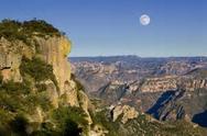
This short (slightly >1 km) section connects the pueblo of San Elias with the turn-off to the old high road from Creel to Divisadero. It generally follows the route of the current highway. By contrast, the railroad (which the trail crossed in the prior section 5) has turned to the east to avoid the El Cajon canyon and is increasingly distant from the trail for the next ~5 kms.
Trail description
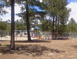
San Elias School
From the water tower as the trail enters San Elias,, the Camino takes a left fork off the access road and continues past several school buildings on the right. Then it turns left on a village road through a gate into a more open farming and residential area on both left and right.
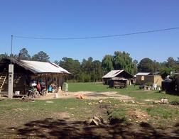
San Elias Homes
After 250 meters the road passes through another gate and further through the trees to another clearing with several houses. Immediately before the clear area, the trail turns sharply left on a track road that descends gradually toward the highway, ending only 10 meters away and then then turning parallel to it, crossing under a barbed wire fence. The vegetation in this portion is low scattered bushes. The trail climbs slowly into some trees until reaching a small clearing on the side of the highway. This is the crossing point to the east side of Highway 77. (27.681117, 107.723681, elevation 2448 meters)
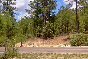
Highway 77 Crossing
At the clearing the trail turns sharply left to cross the highway and enters the pine forest. It climbs through the trees bending right to the top of the small hill. From the top there are views over the El Cajon canyon to the west and over other Tarahumara houses of the San Elias community to the east. The trail goes to the left of the hill summit across a low barbed wire fence and then down steeply (and right) through open low brush vegetation. At the bottom of the descent (and then to the left) there is an open gate. The trail goes through the gate and once again descends steeply for 30 meters across an open clearing. The trail passes through the clearing and then climbs abruptly to the start of the old high road from Creel to Divisadero. The Camino is the road that climbs on the right up from the open area. (27.679138, 107.721080, elevation 2439 meters)
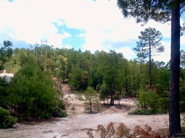
Clearing Before High Road
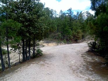
Camino Road on Right